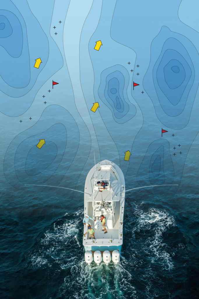
We arrived to the offshore grounds, some 50 nautical miles from North Carolina’s famous Oregon Inlet. The high-definition electronic charting function on our Raymarine e165 multifunction display (MFD) indicated a precipitous drop in the ocean floor with its steep face ushering an upwelling of rich nutrients.
The crew set out the lines as the captain began trolling back and forth across the submerged cliff, setting waypoints each time he noticed bird activity or saw schools of bait on the fish finder. A pattern became clear: The bulk of the life was hanging around the 300-fathom line on the chart plotter. The captain used the shading function to designate this zone. Two hours later that paid off with a hookup on a 300-pound marlin.
Depth-shading technology is just one of the features that help boost your success, whether you’re fishing offshore or close to the coast. “That little chip contains an incredible amount of information that allows you to do much more than just pan and zoom,” says Ken Cirillo, senior manager of light marine sales for the Americas for C-MAP by Jeppesen, in reference to the microSD cards on which electronic charts are contained. “Much of the advanced angling technology available through electronic charts and compatible plotters gets overlooked,” Cirillo says. Here are some examples.
Get It in HD
Today, we know more about seabed contours than ever, and that is reflected in the high-definition capabilities of many electronic charts such as the high-resolution bathymetric (HRB) fishing charts from C-MAP and SonarChart from Navionics.
“The sonar charts function features contour lines for every 1-foot change in depth for inshore areas,” says Shawn Ruge, product manager for Navionics. “Those kinds of subtle differences mean you can more readily find holes on the flats where fish like snook or redfish might be holding.”
Waypoints Aplenty
Recognizing fish patterns on an electronic chart becomes easier if you use waypoints liberally to mark significant events during a day of fishing, Cirillo says.
While drift-fishing a large wreck, for instance, setting a waypoint each time you catch a fish allows you to see where fish are holding. “The more waypoints you set, the more clearly patterns emerge,” Cirillo points out.
“Some plotters let you set thousands of waypoints, although it’s improbable you will use them all,” Ruge explains. “But you can always delete them later, on another trip.”
Shady Deal
Once you recognize a productive depth, the custom depth shading lets you highlight the strike zone. “Whether it’s 2 to 3 feet or 200 to 300 feet, custom depth shading gives you a good idea of where to focus your efforts and catch more fish,” Cirillo says.
Current Events
Moving water ranks as a key factor in triggering feeding activity, and many electronic charts, including C-MAP and Navionics, guide you to where and when this will occur. “The current vectors on C-MAP charts forecast the approximate direction and speed of moving water,” says Cirillo, who uses this function regularly to locate feeding striped bass in his home waters in Massachusetts.
Electronic charts also give you tide station information, but tides and currents are not synonymous, Cirillo points out. “Our electronic charts combine tidal data with other factors to approximate the currents.”
This information shows differently on different MFDs, Cirillo says. “Look for the current vectors on the chart. Some plotters animate the currents; others let you tap on the icon to get a dialog box.”
Ch-Ch-Changes
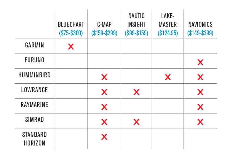
There are a number of ways to update charts, including online systems such as Navico’s GoFree shop (gofreemarine.com) or Navionics’ Freshest Data (navionics.com). If you have a wireless MFD from Navico (Lowrance or Simrad), you can do it automatically aboard your boat.
You can also go to an authorized dealer for an update or call the electronic chart company for an updated card. The most economical way to update your chart is through a subscription. For $59, for instance, C-MAP offers regular electronic chart updates throughout the year.
Knowing how to quickly activate the functions on your electronic chart is critical, Cirillo says. “Practice using the various features for your electronic charts,” he suggests. “The user-interface is different for each MFD, but using features like custom depth shading ought to be second nature for a boating angler.”