4/30 Oil Spill Update from NOAA Assistant Administrator for Fisheries Eric C. Schwaab
We are all watching the unfolding oil spill incident occurring in the Gulf of Mexico and are deeply concerned over the anticipated impacts this spill can have on marine life and the economies which rely on them.
I want to give you a brief summary of NOAA’s and Fisheries’ full engagement in the response process and provide you with a link to a web page NOAA has established through its Office of Response and Restoration where you can be kept informed of daily events.
As you know, on April 20th there was an explosion that resulted in a fire on the Deepwater Horizon, a mobile offshore drilling unit in the Gulf of Mexico ~50 miles offshore Louisiana. The rig burned for hours and then sank. Eleven out of 126 people remain unaccounted for. It was recenlty discovered that there are multiple leaks at a depth of 5,000 feet.
So far, attempts to use remotely operated vehicles to close valves and stop the leaks have been unsuccessful. Construction has begun on a collection dome that will be deployed to the sea floor to collect and funnel oil as it escapes, a method never tried at this depth before. The first rig to be used for drilling a relief or cut-off well has arrived and more are planned. A relief well would take several months to complete.
NOAA has fully mobilized all of its offices. Our experts are involved in predicting where the oil is going and how the weather and sea will affect the oil and cleanup efforts. NOAA experts are also advising the Coast Guard on cleanup options, as well as monitoring and assessing damage to fish, shellfish, marine mammals, sea turtles, as well as critical and essential fish habitat.
NOAA is posting daily updates at noaa.gov. Click on the “NOAA Assists Gulf of Mexico Oil Spill Efforts” link which will take you to the NOAA Office of Response and Restoration page at response.restoration.noaa.gov. I would encourage you to bookmark this page as a key resource of information.
4/30 U.S. Senator Bill Nelson Visits Pensacola, Calls on President to Stop Plans for Expanded Oil Exploration
With much of the Gulf of Mexico coast facing an environmental disaster, U.S. Sen. Bill Nelson is scheduled to meet Friday with officials of this tourism and beach town about steps the federal government and military are taking to protect the area from a giant oil slick increasing in size and spreading from the site of the Deepwater Horizon rig.
Naval Air Station Pensacola is serving as a staging facility for U.S. Coast Guard contractors.
Nelson’s visit comes on the heels of a letter he wrote Thursday to President Barack Obama in which he calls for an indefinite halt to the administration’s plans for expanding offshore drilling operations. Nelson also revealed he’s filing legislation aimed at blocking the administration’s plans.
Oil rigs have been kept from 125 miles to 235 miles away from Florida’s Gulf coast under a 2006 law written by Nelson and former Sen. Mel Martinez.
Earlier this week, the Florida Democrat also called for an investigation into the Louisiana rig disaster by the Senate Committee on Commerce, Science and Transportation.
4/30 Update from NOAA
NOAA now believes that the amount of oil still spilling into the Gulf of Mexico could be five times the original estimated amount – possibly up to 5,000 barrels a day as of Thursday.
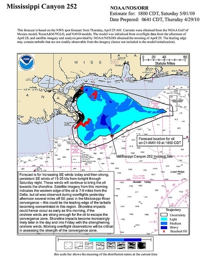
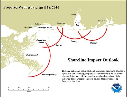
Meanwhile, concern is growing among those who make a living from the sea all along the Gulf coast. The exact impact of the spill is still in question but officials say landfall could come as early as Friday. NOAA is predicting strong southeast winds to continue to push the oil towards shore.
The Coast Guard is reporting that their test burn yesterday was successful. Other containment efforts are still being deployed.
4/29 Update from ROFFS
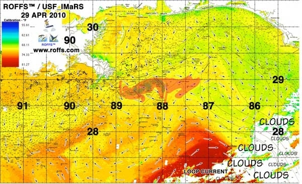
Roffer’s Ocean Fishing Forecasting Service, Inc., (ROFFS?) is sending out alerts to numerous people including legislators, emergency managers, and the fishing community to keep them abreast of the changing nature of the spill and how it might impact the environment along with their fishing or traveling to fishing grounds. Our efforts are similar to their work after Hurricanes Katrina and Rita (roffs.com/katrina.htm). These satellite images and analyses are derived from NASA, NOAA, and European satellites.
We are working with other colleagues from several institutions on this effort. ROFFS? has been interviewed by several newspapers and magazines for their continued monitoring of the ocean conditions related to the oil spill. This and work by colleagues from University of South Florida (optics.marine.usf.edu/events/GOM_rigfire/ and ocgweb.marine.usf.edu ) and Florida Institute of Technology clearly shows the importance of ocean observations from satellites along with buoys, and modeling by non-governmental organizations. These efforts and the work by other oceanographers must be supported to allow these and similar efforts to be continued for the betterment of society.
If we can map the changing conditions it will allow others to prepare with significant advance warning for the eventual landfall of this oil. It is much better to prevent the oil from reaching the coastal zones than cleaning it up after it negatively impacts the ecosystem and substantially affects the economy. The value of a clean coastal ecosystem is tremendous for everyone.
Presently the oil spill is spreading toward Louisiana and the Florida panhandle. While the forecast winds over the next few days (April 29 – May 02) suggest that the oil will reach the Louisiana coast soon, the longer term forecast and longer term spill area projections (ocgweb.marine.usf.edu) suggests that the oil is likely to spread throughout the Gulf of Mexico. When the oil is picked up by the Loop Current it will be transported by the Gulf Stream system to the Florida coastal zones including the Florida Keys, the east coast of Florida and many areas north. It is possible that the oil will move as far as Cape Hatteras in the Gulf Stream.
Note also that while the oil is warm underground the deeper ocean waters are relatively cold. By the time the oil reaches the surface it is cooler than the surrounding waters and we have been able to see the oil due to its cooler signature. As it warms on the surface it becomes indistinguishable from the infrared satellite imagery, but it remains observable using visible satellite data. We remind everyone that subsurface oil and byproducts also present significant problems to the environment.
View the latest alert and maps from Roffer’s Ocean Fishing Forecasting Service, Inc. at roffs.com/deepwaterhorizon.html.
4/28/2010
A growing oil slick in the Gulf of Mexico is continuing to threaten coastal areas, including those around the Mississippi delta in Louisiana and southern Alabama The spill is a result of the explosion of the offshore rig Deepwater Horizon last week, which was operating in 5,000 feet of water.
Authorities are now contemplating a number of containment options, including possibly setting the oil ablaze to burn it off as early as Wednesday.
Coast Guard officials are quoted as saying that “this could be one of the most significant spills in U.S. history” if not contained.
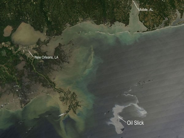
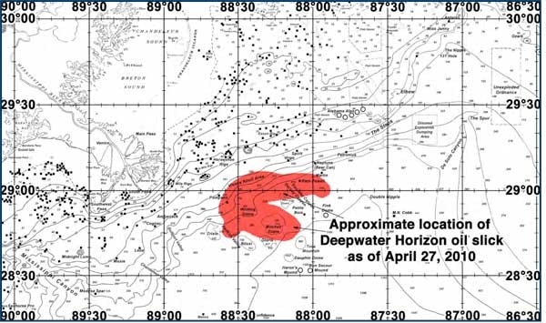
NASA photo of slick taken 4/25/2010
__
ROFFS Fisheries Oceanographic Special Announcement for the Northeastern Gulf of Mexico Area (Lat./Long.)
As many of you are aware, the Deepwater Horizon Rig located at approximately 88°23’W & 28°45’N experienced a series of explosions on board and ultimately sunk last Thursday. As a result of this, the remnants of the rig have been releasing oil, which has now resulted in the depicted oil slick. We have studied a series of imagery consisting of high resolution visible RGB, infrared sst°, and MODIS ocean color/chlorophyll imagery to determine the location of the resulting oil slick.
We are sending this special announcement to let our clients know that as long as this situation continues to affect the environment in the northeastern Gulf of Mexico, we will provide information about it in our corresponding analyses so that you can avoid this area when fishing or travelling to your fishing grounds. We will continue to track this situation on a day to day basis. For more information please call 800 677-7633 or visit roffs.com.