Our boat drifted ever closer to an invisible line in the ocean. On one side, the one we were on, we could legally fish. On the other side, we could not. No signs, no buoys, no overt indicators to tell you that your boat has crossed over into a no-take zone. But this is the law, nonetheless.
Fortunately, thanks to advanced marine electronics, familiarity with the regulations, and a heightened sense of place, we were careful not to cross that line. Yet those who are not aware—or don’t care—and get caught in the wrong spots might face heavy fines, forfeiture of boat and tackle, suspension of fishing licenses, and other penalties.
Such is the danger when fishing in the proximity of marine protected areas (MPAs).
While the West Coast appears to be ground zero for the establishment of MPAs, the number is increasing in many other coastal regions in the United States and elsewhere.
That’s where a chart plotter and up-to-date electronic cartography become even more valuable. Because in the eyes of the law, ignorance is not a defense.
“For a lot of reasons, an advanced electronic chart is a vital tool to successful angling,” says Shaun Ruge, director of marketing and product management for Navionics. “These charts not only tell you where to fish, but also where not to fish.”
Maps and Regs
The first step in avoiding MPAs is becoming educated about the boundaries and regulations for each zone within the region you plan to fish. Maps and regs are published by government agencies that manage marine resources for each area. In the U.S., these are usually the state departments of natural resources, or fish and game. The agencies publish booklets and online materials containing maps, latitude/longitude coordinates and applicable rules.
Another—and perhaps more useful—source, however, are electronic charts from companies such as C-Map and Navionics that are provided online and via mobile apps. On the Navionics website and its app, for instance, you will find a chart viewer. “You can scroll to the area you want to fish, and find the outlined areas that designate MPAs, marine parks, sanctuaries and other conservation zones,” Ruge says. “The tighter you zoom in, the clearer the boundaries appear.”
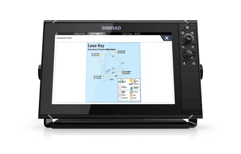
For example, on the ocean side of Islamorada in the Florida Keys, you can find the outline of Alligator Reef Sanctuary Preservation Area on the Navionics chart viewer. As you zoom in, the outline of the area becomes clear, as do the underwater features within. This is a no-take zone, but you can catch-and-release fish by trolling only.
Textual Data
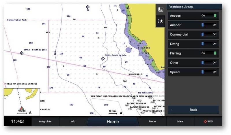
Online and mobile resources also provide critical information about the angling regulations within an MPA. “On the Navionics chart viewer, if you place the cursor over an outlined area and tap, it will bring up an icon containing a question mark,” Ruge points out. “Tap on the icon to bring up textual data such as the name of the area, the applicable regulations and other information.”
The info will let you know whether a particular MPA is off limits entirely to fishing. In California’s Farnsworth Offshore State Marine Conservation Area, which surrounds the productive Farnsworth Bank on the backside of Santa Catalina Island, anglers are allowed to fish for pelagic species such as California yellowtail and Pacific bonito, but not for bottomfish such as lingcod and rockfish.
These pop-up text boxes also tell you that, within the adjacent Farnsworth Onshore State Marine Conservation Area, hook-and-line fishing is prohibited, with the exception of trolling for mahi, marlin and tuna.
Charting Your Way
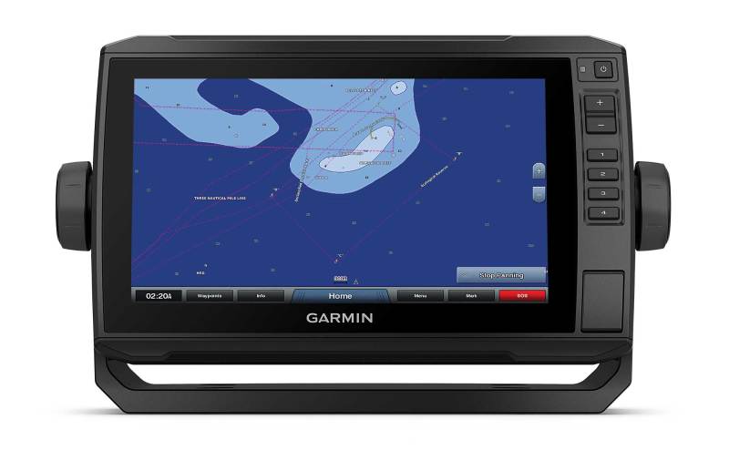
Computers and mobile apps work well when you have internet or cell service. But many MPAs lie outside such coverage areas, and this is where a chart plotter equipped with the most up-to-date electronic cartography becomes indispensable.
Just as with online and mobile chart viewers, electronic charts from C-Map, Navionics and Garmin feature boundaries of MPAs, and other conservation areas and sanctuaries. Equipped with GPS, your chart plotter portrays accurate graphic representation of your boat’s position relative to a nearby MPA.
With the Garmin BlueChart g3 Vision charts, you can also select the recreational fishing mode in the menu of a compatible Garmin model with current software to highlight MPA boundaries and create shading of the area inside so these areas stand out better on the screen.
Like the online and mobile charts, the C-Map, Garmin and Navionics electronic cartography for chart plotters contains textual information that, at the tap of the touchscreen, brings up a description of an area. Thus, if you’re not already familiar or need to brush up on the regs, you can do so from your chart plotter.
Fishing the Edges
Electronic charts also help you catch fish on the outside edges of MPAs, places where species might migrate in and out of the area. In California’s Channel Islands, for example, some captains drift for rockfish along the edges of the Scorpion State Marine Reserve on the northeast corner of Santa Cruz Island. Chart plotters and cartography keep the anglers legal as they work the rich bottomfishing areas adjacent to this no-take zone.
Along the coast of Southern California, anglers also face depth restrictions when bottomfishing. For years, the maximum allowable depth was 350 feet, except for Cowcod Conservation Areas, where the max depth was 120 feet. For the 2019-20 season, however, the state Department of Fish and Wildlife has increased the depths to 450 feet and 240 feet, respectively.
But it’s not as simple as it seems.
In actuality, the margin is defined by a series of coordinates connected by straight lines. It is illegal to bottomfish seaward of these lines, even if you are in less than the maximum depth. To help ensure they remain legal, many anglers create waypoints for each of these coordinates, and then connect them in a route line that stands out from the bottom contour lines.
It’s just one more way to use your chart plotter and electronic cartography to identify and avoid no-fishing zones.
New Electronics