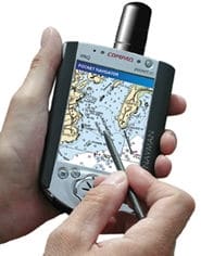
| Maptech’s Pocket Navigator is a full-function navigation-software package that operates on a handheld Compaq iPaq equipped with a GPS-enabled sleeve. |
Aside from the weather at sea, nothing changes faster than electronics and computers. Some of the neatest developments for the boater and fisherman are occurring in the field of navigational software, which, among numerous other things, allows the user to control all of his onboard electronic equipment through a single computer and view the information on one or two display screens. It’s the stuff of science fiction, only it’s available now!
Recently, we had a look at a state-of-the-art marine-electronics system on the bridge of a 57-foot Bertram. Displays consisted of just two flush-mounted screens – one for the radar and one for everything else. All electronics were “black box” units that fed data into a central processing unit (essentially a marinized personal computer), where it was combined, controlled, managed and displayed using navigational software. The data display could be controlled via a flush-mounted, waterproof directional keypad that performs the functions of a mouse and is located within easy reach of the helsmsman. While underway, the keypad allowed the user to scroll through the various screen menus. Any commands that couldn’t be handled by the keypad were made on a wireless, weatherproof keyboard that stowed away until needed. The whole arrangement was clean, simple and compact.
It’s a good bet that this is the way all marine-electronics systems are going to be set up. Individual, “stand-alone” units are likely to go the way of the dinosaur, or maybe stick around to fill specialty niches. Hardware is developing rapidly: weatherproof displays are available in a range of sizes, and a waterproof mouse can be used to control the system through point-and-select menus. It’s no longer a situation where you have to carry your laptop onboard and make it do marine duty belowdecks. Of course, that’s still an option, but the point is that the equipment is changing rapidly and becoming more and more applicable to smaller boats.
The Heart of the System
The heart of a modern onboard electronics system like the one we tested is the navigational software. Basically, it’s the software that, when loaded on a PC (or a marinized CPU) and linked to a GPS, becomes a chart plotter. On steroids. Off the shelf, dedicated chart plotters do their job well, but they have only enough memory to handle their main function. However, when you link your GPS to a PC with the appropriate nav software, you get a chart plotter with virtually unlimited capacity to handle data from a number of sources, integrate it, store it and display it in a variety of ways and locations.
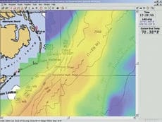
Raymarine’s RayTech Navigator allows users who subscribe to the company’s Fishing Pro service to overlay their navigation charts with plankton-concentration and sea-surface-temperature (shown) charts.|
Because it has so much capacity, the PC essentially becomes a command center for all onboard electronics and can manage them individually and interactively in an unlimited number of ways through NMEA 0183 protocol incorporated in the software. You maintain the control and versatility that comes with a personal computer.
The elements of such a system are pretty straightforward. First, you need the chart sets, or cartography, software. These come in either raster or vector format. Raster charts are basically scans of NOAA paper charts, a graphic image that includes all the information on the printed original. You cannot isolate particular elements such as lights, bottom contours and landforms with raster cartography. You see everything that’s on the chart all the time. About the only layer you can add is your own course and waypoints.
Vector charts, on the other hand, feature different layers of data that can be turned on or off to provide a visual display of only the information you want to see at any given time. Both vector and raster cartography packages can be used to plan trips, assemble custom routes and print out customized charts.
Once you link a GPS to the cartography package through the computer, you have a real-time chart plotter, as opposed to simple planning software. Add an autopilot and depthsounder to the mix and you create a powerful navigation and fishing system. Download information from the Internet – such as weather overlays, sea-surface temperatures, ocean currents and plankton concentrations – and this becomes part of the visual presentation. And your fishing arsenal.
Radar & Sounder Images
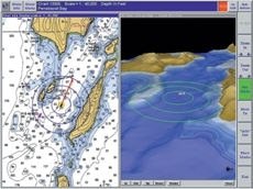
The Capn offers an optional three-dimensional bathymetric charting system that can be viewed on a split screen with a more traditional chart view.|
There are two things the nav software alone won’t handle: depthsounder and radar imagery. Since both of these transfer as a video signal, they require a high-speed bus to convey the image to a remote screen.
Some manufacturers offer this high-speed-bus transfer. There are no standards on video-transmitting hardware, so each company provides its own gear that may or may not work with other manufacturers’ electronics.
Without the bus you may be able to display depths on your charts and track objects with the radar, depending on your nav software, but you can’t transfer the graphic image of the water column or the radar scan to your remote display. It’s something to be aware of if this feature is important to you.
Perhaps the hardest part of understanding navigational software is getting past the jargon, the proprietary names, acronyms and buzzwords -most of them copyrighted by the manufacturers. Don’t let them discourage you. Once you know the lingo (see sidebar on page 35), comparing apples to apples is simple, and you’ll begin to see how many cool things you can do with this rapidly developing technology.
Here’s a look at some of the navigational software packages currently on the market:
The Capn ($495) from Nautical Technologies is well known because it’s the system used by the U.S. Coast Guard. It’s a PC-based workhorse that supports SoftChart and PhotoNavigator photo images (both from Nautical Technologies), as well as BSB/ NOAA, CHS/NDI and Maptech cartography. Options to The Capn include seamless chart integration, 3-D Calypso (a 3-D bathymetric charting system), electronic cruising guides for the East Coast, and a video add-on that displays images from a remote video camera. The program interfaces with other onboard electronics via NMEA 0183. Nautical Technologies, Bangor, ME, (207) 942-4751; www.thecapn.com.
NavPak Professional Edition ($225) from Global Navigation Software is a no-frills program that supports Maptech, BSB, ChartKit, NDI, NOS, SoftChart and Geo-Tiff cartography, as well as user-scanned charts and maps that can be calibrated with the MapSetup software included with the program. NavPak handles data input from up to four serial ports simultaneously, and includes a video window to interface with radar or a video camera using a regular PC Video Capture card. The software also includes freehand drawing tools, which can be used to save annotations as a Windows Metafile. Global Navigation Software, San Diego, CA, (619) 225-0792; www.globenav.com.
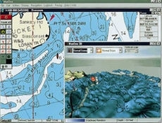
NetSea’s MaxSea Navigator assembles a personal bathymetric database in real time with data from a depthsounder.|
Offshore Navigator 2002 ($199.95) from Maptech provides a complete set of planning and plotting features for raster cartography that turn a PC into a powerful chart plotter. When linked to a GPS, the plotter provides real-time data that can be overlapped with digitized NOAA charts, aerial photos, contour 3-D charts and coastal topographic charts. The new Spherical Horizon View provides an image that Maptech says is like “draping a NOAA chart over a beach ball.” This feature provides a easy way to look ahead and line up a course that takes you where you want to be, such as when following a canyon. Additionally, the On Water mode offers a simplified way to pull up just the information needed in order to navigate on the fly, while at the same time providing a view of the pre-planned course for comparison.
Another software package, Pocket Navigator, is made for the CE operating system on pocket PCs. It integrates with the Navman GPS built for the Compaq iPaq, providing a handheld version suitable for small boats and which also supports Maptech’s Contour Professional 2002. Maptech, Amesbury, MA, (978) 792-1000; www.maptech.com.
MaxSea Navigator ($395) from NetSea supports both Windows and Power Macintosh operating systems and features raster-chart compatibility with cartography from Maptech, Chartpack and Chartkit, NDI, Softchart, Mapmedia, ARCS and NOAA. Vector compatibility, in Windows only, extends to C-MAPNT and CM93 cartography. Add-on modules to the main program allow for a variety of bathymetric constructions and functions, including the assembly of a personal bathymetric database that displays in both 2-D and 3-D, and is assembled real-time from depthsounder data. All electronics are linked via NMEA 0183. NetSea, Inc., Marstons Mills, MA, (877) 563-1177; www.maxsea.com.
Nobeltec’s Visual Navigation Suite covers all the bases by including charting, GPS, tide-and-current tables and autopilot information in a single package.|
The heart of Nobletec’s navigational software is the Visual Navigation Suite ($489), which operates on a PC platform and includes electronic charting capabilities, GPS integration, tide and current tables, and autopilot support. The Navigation Suite supports not only Nobeltec’s Passport vector cartography, but also most raster cartography, such as that provided by Maptech, Softchart and aerial photo programs. Of special interest to anglers is the Fishing Plus Pack, an add-on that makes GPS-loran conversions and receives NMEA data histograms and ARPA radar support. Other add-ons allow for weather-information downloads and the viewing of 3-D bathymetric maps. Radar information can be displayed split-screen, or as an overlay with the Insight Radar option and a Nobeltec radar.
The Nobeltec Admiral ($1,199) is a professional navigational software package that includes all the features of the Visual Navigational System, with additional features and a graphic display presented in a different format than the Windows appearance of other Nobeltec packages. Passport charts and VNS navigational software are also compatible with CE operating systems used by hand-held, miniature PCs such as the Compaq iPAQ. Add a Navman GPS sleeve and you have a PC-based navigational system you can hold in the palm of your hand. Nobeltec, Portland, OR, (800) 946-2877; www.nobeltec.com.
Raymarine’s basic RayTech Navigator Version 4.0 has been specifically tailored for anglers with the Fishing Pro ($799), which operates on a PC platform and supports vector charts via C-MAPNT cartridges or CD-ROM and raster charts from both SoftChart and Maptech. The Fishing Pro features a DataTrak module that allows the user to display incoming, real-time data such as plankton maps and sea-surface temperatures, either independently or overlaid on the charts. Chart-layer merging provides multiple data overlays, which can then be tuned by increasing or decreasing the image density of each layer. The add-on Pathfinder PC provides a high-speed video transfer that allows any onboard monitor to display full, real-time radar and depthsounder images, along with other plotter and autopilot functions. This option provides complete control of both depthsounder and radar from any display in the network, and allows the user to display the information on either a split screen or by overlaying it with other graphic data. Raymarine, Nashua, NH, (603) 881-5200; www.raymarine.com.
| Techno SpeakThe manufacturers of, as well as those who report on, high-tech marine software and electronic gear frequently rely on esoteric language that can make it hard to understand the products and features being discussed. In an effort the clear up some of the confusion, here is a layman’s guide to some of the terms you are likely to come across as you shop for software – or simply seek to understand this fascinating technology.ARPA: Stands for Automatic Radar Plotting Aid. ARPA tracks a target – such as another boat – on radar and displays it on the chart plotter as the target moves or stops its forward direction, as a boat might do when it hooks a fish. This information can be transmitted through NMEA 0183 protocol and does not require a high-speed video bus.Bathymetric: Refers to sea-bottom topography. Cartography with bathymetric construction displays a simulated 3-D picture of the contour of the sea bottom, viewed from a low oblique angle.Black box: Refers to an instrument that collects data but does not have its own display screen. Instead, it sends information to a remote location for display.BSB/NOAA: BSB is a format owned by Maptech to produce electronic cartography derived from NOAA charts.CE: This is an operating system designed for miniature, handheld computers.CHS/NDI: Canadian Hydrographic Service, official publisher of marine and navigational charts in Canada, equivalent to NOAA in the U.S. NDI stands for Nautical Data International, Inc., the company that produces an electronic version of these charts.CPU: Central processing unit, as in the box part of a computer.ECS: Electronic Charting System.High-speed bus (HSB): Has nothing to do with urban rapid transit. In nav software, the HSB a high-capacity system that transfers the large data loads required by video, such as the color profile you see on an depthsounder or the rotating sweep of a radar. Both of these images must be transmitted as a video signal, which requires a higher speed transfer system than that offered by NMEA 0183. There is no universal system – referred to as “open standard” – between manufacturers, so each high-speed bus must be reviewed to be sure it’s compatible with the instruments you need it to work with.NMEA 0183 protocol: National Marine Electronics Association, a trade organization, establishes standards for transmitting data. NMEA 0183 is a protocol that allows data to be shared between different instruments and provides a hardware/software link between marine electronics made by different manufacturers.NOAA: Stands for National Oceanographic and Atmospheric Administration, the U.S. government agency that publishes standard nautical charts. NOAA charts are in the public domain, and not protected by copyright.NOS/GEO: Another charting format used by SoftChart.Platform: The type of machine the software operates on, usually either MacIntosh or IBM PC.Quilting: The process of electronically joining individual raster charts so they appear seamless on a chart plotter screen, moving from one to another even as the orientation and scale of the original changes.Support: When software “supports” something, it means it works with it. |