¿
¿
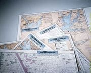
Captain Segulls has recently announced the introduction of five new laminated charts. They are: Cape May, NJ to Hatteras, NC (an offshore canyon chart); Coastal Delaware, Maryland & Virginia; Coastal Virginia to North Carolina; Upper Chesapeake Bay; Middle Chesapeake Bay. Each chart features loran and lat/lon overlays, highlighted fishing hot spots, launch-ramp and fuel-dock locations, and more. Also new is a laminated ID chart depicting popular sport fish of the North Atlantic. Captain Segulls, Portsmouth, RI; (888) 4SEGULL.