Advertisement

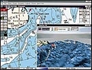
MaxSea 3D Sportfishing Software

maxsea.jpg

Unlike the competition, MaxSea Sportfishing is not a separate program. Both the “chart texture” display and the navigation chart itself are displayed in 3D. The program includes MapMedia World Bathymetric Charts, which provide precision charts, and MaxSea Yacht, a worldwide navigational software that provides GPS input, the download capability of current weather files to be overlaid onto nautical charts, as well as tide and current information. NetSea, Pocasset, MA; (508) 563-1177

Advertisement

Email Newsletters and Special Offers

Sign up for Salt Water Sportsman emails to receive news of the latest techniques for big and small game fishing and the hottest fishing destinations as well as special offers on behalf of Salt Water Sportsman’s partners.

By signing up you agree to receive communications from Salt Water Sportsman and select partners in accordance with our Privacy Policy. You may opt out of email messages/withdraw consent at any time.

More Gear

Advertisement