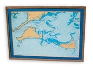
C-MAP is now offering high-quality color prints of its detailed digital charts. All the detail from C-MAP’s NT+ electronic charts is shown in vivid color, including coastal areas and islands, spot soundings, depth contours, hazards, shipping lanes and more. Two versions of prints are available: unframed 36″ by 24″ ($45), and framed and matted 40″ by 28″ ($299). Areas currently available include Cape Cod and surrounding islands, San Juan Islands, Straits of Florida, Channel Islands, Chesapeake Bay, Puget Sound, Shilshoe Bay area, Prince Edward Island/Northumberland Strait, and Coast of Maine. Other areas may be available upon request. C-MAP/USA, Mashpee, MA; (508) 477-8010; www.c-map.com.

Click here to buy C-Map products. |


