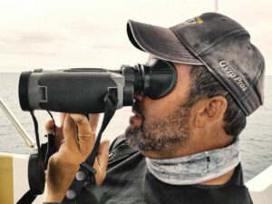
The Viking 65 cruised along at 32 knots as I climbed the bridge to see the skipper and the owner scanning an array of four 15-inch LCD displays. The plotter showed the boat transiting the course line, radar targets overlaying a chart with a three-dimensional representation of the bottom layered beneath. The second display featured radar and the third had sonar. On the last, the owner viewed a split-screen image that included live video of the diesels chugging away in the engine room, digitally created gauges tracking engine functions and a satellite link to Bloomberg Television with a stock ticker across the bottom.
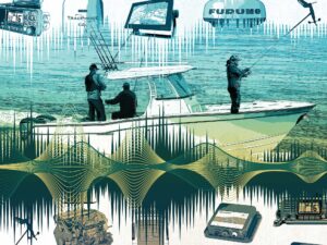
From big-boat super systems to compact, waterproof multi-function units that fit the smallest center console, today’s marine electronics bring more plotter and fishfinder capabilities to fishermen on any size vessel. This compilation provides a starting point for research into what is available today and in the future.
1 Hot Combination
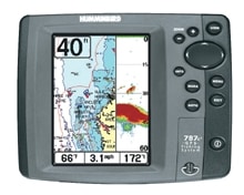
New for 2006 from Humminbird is the 700 Series Professional-Grade Fishing System with SystemLink to interface multiple units, which includes two color and three monochrome LCD versions, all with five-inch screens. The top-of-the-line model is the 787c2 ($699), a combination fishfinder and chart plotter with a color-TFT display. It has a built-in background UniMap, but serious anglers can upgrade to Navionics Gold or HotMaps cartography through an expansion port. The unit has a 16-channel WAAS-enabled GPS receiver, a wide-coverage Dual Beam PLUS transducer and 500 watts RMS for reliable performance to 1,500 feet. The 787c2 can handle up to 2,000 waypoints, 50 routes, 25 tracks and 20,000 points of interest. Through SystemLink you can add subscription weather service, a wireless sonar link and a PC connection for uploading and downloading data. Humminbird; (334) 687-6613; www.humminbird.com
2 Wide Range
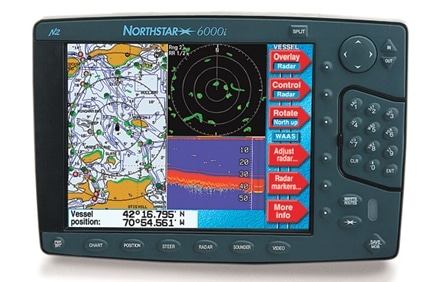
Acquired by Brunswick Corporation, Northstar and Navman are taking aim at all areas of the boating spectrum. Northstar is adding a super-wide 15-inch monitor ($7,995) to its 6000i line that already includes 6.4- to 10.4-inch sizes. The system seamlessly integrates a GPS plotter, sounder and radar across single or multiple displays and can handle video input from cameras or satellite-link television. Sounder and radar modules are sold separately.
The value-packed Navman units are geared to small and midsize boats. The TrackFish 6500 (not shown, starting at $749), is a five-inch color-VGA-screen version of the larger Tracker 6600. Built to offer navigational and fish-finding power in a console-friendly unit, this dual-frequency sounder can reach 1,000-foot depths while the plotter comes preloaded with a 32 MB world map with enhanced navigation details. Northstar; (800) 628-4487; www.northstargps.com Navman; (866) 628-6261; www.navman.com
3 Great Performance
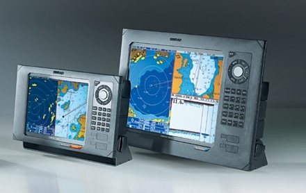
The new CX NavStation is Simrad’s vision of the fully integrated helm, available in three screen sizes, ranging from the seven-inch CX34 ($2,520) to the 15-inch CX54 ($6,995). All feature Slimline TFT color screens that reduce glare, eliminate condensation and expand viewing angles with SunView backlighting. The NavStation combines a differential GPS and chart plotter with sonar and radar. The NavStation operates with the latest C-Map MAX cartography. Radar function is built in, so just plug in the DX45 ($1,805) with 28-mile range or the DX60 with 36-mile range ($2,510). The DX series radars offer MultiVision, which allows two radar scans, one close and one long range, on a split screen simultaneously. Speed Adaptive Antenna Rotation enhances radar effectiveness: As boat speed increases, the unit adjusts the speed of antenna rotation for faster updates, a great safety and performance feature. Simrad; (425) 778-8821; www.simradusa.com
4 Look Ahead
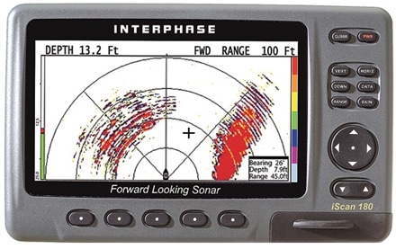
Interphase is probably best known for its compact scanning sonar units, and the introduction of its cutting edge iScan 180 ($2,899) carries on that tradition. This forward-scanning unit uses two transducers to provide a full 180-degree horizontal and vertical view of what’s ahead with radar-like images on a seven-inch sunlight-viewable color LCD. The unit gives readings out to 1,200 feet, which makes it a great navigational tool for avoiding hazards or tracking schools of fish. The iScan 180 can also be used as a monitor for the company’s new Fish Cam underwater video camera. Interphase Technologies; (831) 477-4944; www.interphase-tech.com
5 Storm Watcher
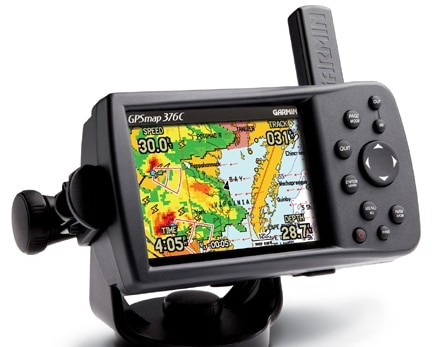
Looking out for trailer-boat fanatics, Garmin has introduced the first crossover GPS plotter that goes from the dashboard to the helm. The GPSMAP 376C ($1,000) features a 3.8-inch color TFT LCD screen, a GMX 30 Smart Antenna, a lithium ion battery and car charger for the street; and a GMX pole antenna with power and data cables to interface with the electrical system and other electronics on your boat. The 376C can store 3,000 waypoints, 50 reversible routes, a 10,000-point auto track log and 15 saved tracks. The unit has alarms for anchor drag, off course and proximity waypoint warning. It can display animated NEXRAD weather radar and forecasts, current conditions, wave data and surface temperature charts with a subscription to XM. The background map includes land-based highway data for the U.S. and is compatible with Garmin BlueChart marine cartography. Garmin; (913) 397-8200; www.garmin.com
6 Hard Driver
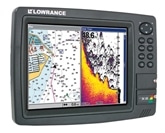
Lowrance has been introducing new products at a blistering pace. The company added 20 GB hard drives to their top-of-the-line chart and combo units, such as the LCX-111C HD ($2,299) and GlobalMap 7600c HD (not shown, $1,999). They come loaded with new proprietary NauticPath cartography. Using LowranceNet integration, these devices can be programmed to show on multiple LCD units and incorporate any of the five new radar arrays, as well as digital gauges for your engines and much more. The units with sonar also sport a new 83/200 kHz Dual-Search transducer that provides a full 120-degree sonar cone at 83 kHz capable of marking fish from a much wider path beneath the boat. Lowrance; (800) 324-1356; www.lowrance.com
7 Black Magic
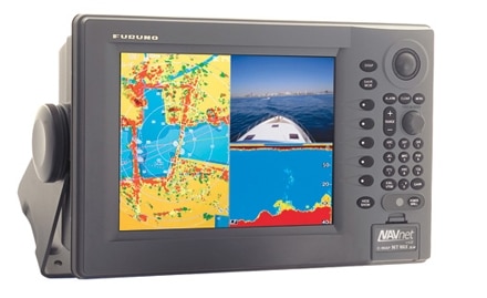
The buzzwords at Furuno are “black box,” which refers to separate units that provide different functions but show data on a common display, rather than each using its own screen. The NavNet vx2 system is based around 12.1-inch ($4,995) or 15-inch ($6,495) color LCD monitors with chart plotters. Black box add-ons provide all functions that work in versatile single- or multiple-screen modes. Add the BBWGPS ($350), a WAAS-enabled GPS module, and choose between the BBFF1 ($795) dual-frequency sounder with up to 1 kilowatt of selectable power and the BBFF3 ($2,295) sounder with variable frequencies and up to 3 kilowatts of power for performance down to 3,600 feet, and fish cannot hide. A choice of radars and Weatherfax round out the Ethernet-based system. Furuno; (360) 834-9300; www.furunousa.com
8 Fine Charts
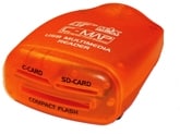
Much of the excitement at Raymarine is about software, from the Raytech RNS Version 6 Navigational Software ($699) to groundbreaking multi-dimensional cartography for their E-Series navigational displays. Raytech RNS 6.0 is fully compatible with E-Series onboard systems. This software runs on Windows 2000 or XP and includes charting, worldwide tides and currents and can even be used for optional live radar and sonar integration. It can interface with onboard electronics through NMEA 0183, SeaTalk or hsb2, which can make a laptop the full command center for the entire boat. The E-Series (not shown, starts at $3,200) will now run the Navionics Platinum Cartography package, but with some features exclusive to Raymarine. It provides 3-D bathymetric charting, top-down aerial photo charts of nearshore areas with adjustable, transparent overlays, panoramic navigational photos of harbor entries, detailed vector charts, an expansive and expandable database of wrecks and more. Those that purchased an E-Series system can get a free download available at the Raymarine website that will upgrade the unit’s software to handle Platinum. Raymarine; (800) 539-5539; www.raymarine.com
9 Keep in Touch
Well known for navigational software, Maptech has entered the hardware market with the i3, an integrated navigation-information system billed as the simple answer to complex systems. The i3 is an all-in-one unit equipped with either a 12-inch ($12,999) or 15-inch ($14,999) color LCD touch screen. Gain access to all functions and modes, including the optional black-box fishfinder ($1,199) and radar units (from $3,900 to $9,000), with a fingertip. The i3 comes with a full complement of vector navigational charts and the popular Contour 3-D bathymetric bottom charts with WAAS-enabled GPS. The system can be expanded to include up to four video cameras, an entertainment system and more. Maptech; (888) 839-5551; www.maptech.com
10 Deep Thoughts
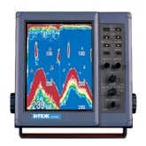
Si-Tex has two eight-inch color LCD sounders, the CVS-833 ($1,699), a 600-watt RMS unit good to 2,000 feet, and the CVS-833C (not shown, $1,899), a 1,000-watt RMS version for depths to 4,000 feet. Both feature 16-color daylight-viewable displays with selectable contrasting background colors and dual-frequency operation. Rotary-switch controls allow for quick mode, gain and brightness adjustments, and a bottom-discrimination function allows a better view of seafloor composition. Si-Tex Marine Electronics; (727) 576-5734; www.si-tex.com
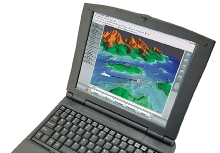
To Helm and Back
Despite their sophistication, modern navigational electronics are simple to operate, thanks to the ability to program them from a PC. When I upgraded to a Lowrance LCX104c chart plotter, I fell in love with a program called MapCreate 6 and the included memory-card reader-writer. Using a basic chart, I input data from my logbook – wrecks, structure, waypoints and routes, including names, descriptions and icons – on my home computer. Then I loaded them into the plotter via the card slot. The information then appeared as icons on the Navionics chart. These tools will continue to improve, but the most basic computer-boat unit interface helps manage angling information better. So when you’re aboard, you can concentrate on fishing.
– G.C.