“Everybody talks about the weather, but nobody does anything about it.”
– Charles Dudley Warner
Information about upcoming weather is the mariner’s first line of defense when it comes to planning productive and safe fishing days.
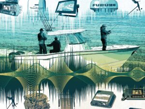
There’s a line of escalating technology to help you acquire that information, and ultimately you can get in as deep as you want.
The first step is the Weather Channel on TV – which lets you know if you are going to need your slicker at the marina, but that’s about all.
Then there is the grandaddy – NOAA weather. How many of us use the comforting drone of the NOAA weather broadcast coming out of a $50 receiver from Radio Shack for our bedtime lullaby and O-dark-thirty wake-up call?
The same NOAA broadcast comes through the WX channels on your VHF once you are on the water. The addition of weather alerts incorporated into most VHF radios automatically lets you know when NOAA has issued weather warnings or watches and that it’s time to pay special attention.
A great night-before or early morning check-in when your fishing is going to carry you beyond the sight of land is the National Data Buoy Center (ndbc.noaa.gov). Hundreds of sea buoys anchored offshore provide real-time wind and sea-condition data, and it’s all available online.
Eyes in the Sky
The last couple of years have seen a tremendous growth in satellite weather services, in particular Sirius and XM radio.
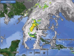
With a basic weather-package subscription to either one, weather maps are broadcast to the receiver – in the case of fishing boats, to the chart plotter – and are geo-tagged to overlay the navigational image on the multifunction display (MFD). Choice of data display is extensive on both services and includes radar, sea-surface temperature and conditions, lightning strikes, buoy information, storm tracks and a range of forecast parameters.
Chart plotters come equipped to handle transmissions from both Sirius and XM weather services. Sirius, whose service is provided by WSI, a sister company of the Weather Channel, is available on plotters made by Raymarine and Furuno in addition to those made by the Navico companies: Northstar, Simrad, and Lowrance. XM, with information provided by WeatherWorx, an independent service, is compatible with Garmin and others – mostly navigational software suppliers.
Recently, the two services, Sirius and XM, merged. So the big question is: What effect will this merger have on the fishermen who now use the services?
For the time being, expect no effect at all.
“We are not going to change anything,” says Mike Hooper, manager of advanced applications and services for XM. “Your particular device will not become inoperable just because we have a weather data service and Sirius does too.”
Down the road, the merger may allow subscribers to pick and choose from a menu of services now restricted to either WX or Sirius subscribers. Once the merger sorts itself out, common sense suggests the combined company may not want to maintain two independent satellite systems and redundant weather services. Insiders at both XM and Sirius are touting the advantages of their particular weather systems. But at some point it will likely come to a battle of the bandwidth, and mariners will be offered the service that prevails.
For now, though, the same partnerships with particular plotter manufacturers will remain, and the fisherman accustomed to a particular satellite weather service can carry on as usual.
Satellite weather from either company provides current information in about as many forms as most of us will ever need. However, if you have your sights set on the horizon, bear in mind that satellite weather is only reliable about 100 miles offshore. Mileage may vary depending on equipment. Users report varying reception in far-flung locales, but that’s incidental. If you are fishing Central or South America or the Baja Peninsula, getting the same level of reliable weather information becomes a little more complicated.
At Sea
The next step up in weather information moves into the realm of single-sideband radio, satellite transmissions and radio fax broadcast by NOAA (weather.noaa.gov/fax/marine.shtml) and other members of the international community.
Access depends on an onboard PC in most cases or at least a dedicated receiver that handles the transmissions. Furuno offers Fax30, a single-sideband receiver and interpreter that will output the transmitted images to their NavNet system. Graphic images are not keyed to navigational information on the chart plotter but appear as stand-alones.
Raymarine offers the RayTech option. RayTech is their navigational software that has the ability to render compressed graphics or GRIB files generated by NOAA into displayable meteorological charts.
Once you’re in the realm of SSB, PCs and satellite communications, you need equipment, software support and training to get the most out of a globally accessible weather information system. It’s a complicated arena, but the onboard PC has made a lot of things easier in many ways. “In this day and age [of onboard PCs], the single-sideband receiver is not as essential as it used to be,” says Mark McNamara of Landfall Navigation, an electronics retailer in Stamford, Connecticut.
Systems and software options are abundant once you add a PC to the helm. There are a number of private subscription weather-service providers, such as OCENS (http://ocens.com/weather.htm) and Global Marine Network (http://globalmarinenet.net) that tailor services to marine global-weather information when safe transoceanic passage becomes more important than finding fish.
Homemade Predictions
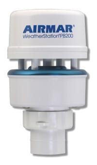
Armed with VHF and a satellite weather subscription, most anglers will have all the information they need right at the helm. Want to do your own forecasting? Both Airmar’s PB200 and the Maretron WSO100 are miniature weather stations you can put on your boat to provide wind speed and direction, temperature, barometric pressure and humidity. The PB200 ($1,495) outputs both NMEA 0183 and 2000 at the same time for interconnecting with a variety of other components. The WSO100 ($910) is NMEA-2000 equipped.
Your weather forecasting may be just as accurate as anyone else’s predictions, and they’ll be in very real time.