Close

Login

Logging In
Invalid username or password.
Incorrect Login. Please try again.

not a member?

Signing up could earn you gear and it helps to keep offensive content off of our site.

September 21, 2007

MaxSea 3D Sportfishing Software

maxsea

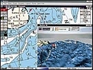
Unlike the competition, MaxSea Sportfishing is not a separate program. Both the "chart texture" display and the navigation chart itself are displayed in 3D. The program includes MapMedia World Bathymetric Charts, which provide precision charts, and MaxSea Yacht, a worldwide navigational software that provides GPS input, the download capability of current weather files to be overlaid onto nautical charts, as well as tide and current information. NetSea, Pocasset, MA; (508) 563-1177

post a comment
  • Anonymous comments will appear after it has been approved by a moderator.
  • Login or Register Now for your comment to appear immediately.
Please note: your comment will appear after it has been approved by a moderator. If you login or register your comment will appear immediately
The content of this field is kept private and will not be shown publicly.
All submitted comments are subject to the license terms set forth in our Privacy Policy and Terms of Use